Next generation ice-sheet bed measurements
Theo Murphy meeting organised by Professor Martin Siegert, Professor Richard Alley FRS, Professor Dorthe Dahl-Jensen and Associate Professor Christine Dow.
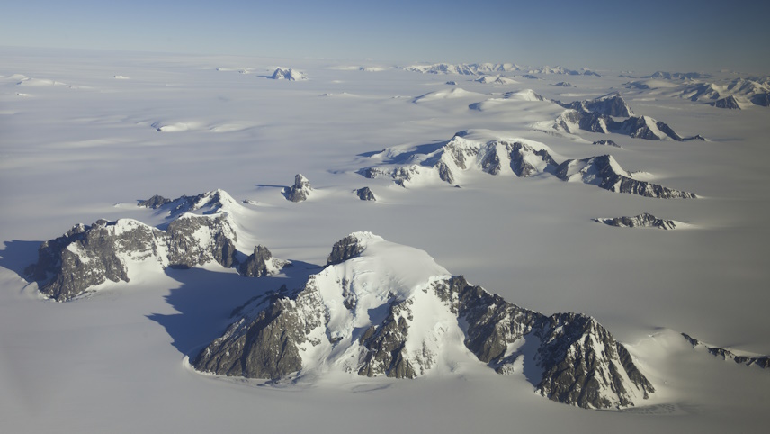
Projections of sea-level rise under strong warming are greatly uncertain, with estimates for 2100 varying by more than 1 m and far greater thereafter. Of the sources of uncertainty, lack of knowledge of ice-sheet bed topography and material composition is important and addressable, but requires coordination to focus on the most important regions in a timely manner. This meeting will discuss the benefits of bespoke optimised surveys of the polar ice sheets, the technology available to conduct it and the international collaborations, logistics and permissions necessary to make such surveys possible.
Please note the programme may be subject to change.
Attending this event
- This meeting is now fully booked
- Free to attend and in-person only
- Catering options will be available to purchase upon registering. Participants are responsible for booking their own accommodation. Please do not book accommodation until you have been invited to attend the meeting by the meeting organisers
Enquiries: contact the Scientific Programmes team
Organisers
Schedule
Chair
Professor Martin Siegert
University of Exeter, UK
Professor Martin Siegert
University of Exeter, UK
Martin Siegert is a glaciologist, geophysicist and climate scientist. He uses geophysical measurements to investigate the flow and form of large ice sheets, and to understand processes operating in the past, now and in the future. He has published on subglacial environments, including on subglacial lakes, and on the history of the Antarctic ice sheet and continent. He has been a UK delegate to SCAR, and has led several SCAR activities and programmes. He was awarded the 2013 Martha T Muse Prize for Antarctic Science and Policy. He led the Grantham Institute at Imperial College London between 2014 and 2022 and is now Deputy Vice Chancellor (Cornwall) at Exeter University.
| 09:00-09:05 |
Welcome by the Royal Society and lead organiser
|
|---|---|
| 09:05-09:30 |
Mapping subglacial topography: from simple interpolations to physics-informed approaches
Subglacial bed topography is a critical input to understand the stability of ice sheets and for computer models to provide reliable estimates of future seal level rise. These topography maps are constructed based on line measurements collected by airborne radars. These measurements generally provide information only directly underneath the aircraft, and the bed topography in-between measurements has to be interpolated. The first maps of bed topography were constructed based on little data, and using very simple interpolation methods. Since the 2010s, significantly more data have bene acquired by different international agencies, and novel, more advanced interpolation approaches have been proposed. One of them is the use of mass conservation, which combines the radar information with satellite-derived ice flow speed and the principle of conservation of mass. This approach makes it possible to estimate how the bed topography changes in between flight lines by using other datasets for which we have complete coverage. Other new methods involving machine learning, surface features, or stochastic modelling have also been proposed. In this talk, we review the evolution of mapping method over the last 20 years, since the first release of Bedmap, discuss the benefits and limitations of different techniques, and provide inputs for how these maps are continuing to improve our ability to model ice sheet flow and their future contributions to sea level rise. We also discuss how future field campaigns should be designed to optimise these new mapping techniques. 
Professor Mathieu MorlighemDartmouth College, USA
Professor Mathieu MorlighemDartmouth College, USA Mathieu Morlighem is a Professor in the Department of Earth Sciences at Dartmouth College. His research interests are focused on better understanding and explaining ongoing changes in the Cryosphere, as well as reducing uncertainties in the ice sheet contribution to sea level rise using numerical modelling. He is one of the founders and core developers of the Ice-sheet and Sea-level System Model, a new generation, high-resolution, higher-order physics Ice Sheet Model. He also developed and maintains BedMachine, a high-resolution subglacial bed topography dataset of the Greenland and Antarctic ice sheets. |
| 09:30-09:55 |
Lessons learned from Bedmap3, and the challenges to overcome in automating Bedmap4 and beyond
It is tempting to think that the key challenge in generating new Bedmaps is to re-run an interpolation algorithm with an ever-enlarging dataset of ice sheet thickness, as new airborne surveys are completed. This does help, but other challenges emerge. Surveys often don't agree, large data gaps remain, the ice thickness changes, algorithms work well for one landscape but not another. Similar problems afflict other key Bedmap components: the coastline, the grounding line, the ice shelves, and the bathymetry. The process of merging the interpolated ice sheets and shelves, and the grounded bed with the sea floor, can also inject spurious cliffs and bumps in the grounding zone - exactly where ice sheet models are most dependent on accurate boundary conditions. In each case, the unintended errors and artefacts that arise require careful checking, correction, and sometimes bespoke, local approaches to the interpolation. Can Bedmap be automated? Probably, but each of these challenges must be understood and overcome in ways that are robust to the data thrown at them. And it might still be quicker to do it by hand. 
Dr Hamish PritchardBritish Antarctic Survey, UK
Dr Hamish PritchardBritish Antarctic Survey, UK Dr Hamish Pritchard is a glaciologist at the British Antarctic Survey specialising in mapping, monitoring and understanding the cryosphere through remote sensing, field surveys and instrumentation. His research targets the two outstanding icy issues facing the world as the climate changes: sea level rise, and the fate of mountain water resources. He was a lead author on the IPCC Special Report on Oceans and Cryosphere and currently leads Bedmap3, re-mapping the hidden bed of the Antarctic ice sheets, and the Natural Environment Research Council project ‘The Big Thaw’, filling gaps in our knowledge of mountain snow and ice. |
| 09:55-10:20 |
An evaluation of synthetic bed topographies for ice sheet modelling
Bed topography plays a pivotal role in shaping the evolution of the Antarctic Ice Sheet, controlling ice flow dynamics, grounding line retreat, subglacial hydrological processes, and ice shelf melt rates. Despite its importance, Antarctic bed topography remains sparsely sampled, resulting in significant uncertainties in bed datasets that propagate in ice sheet model simulations. Synthetic bed topography datasets, generated using mass conservation methods, geostatistical approaches, and other multi-method integrations, are increasingly utilised ice sheet modelling applications. Here, we explore the role of synthetic bed topographies in advancing ice sheet modelling. We review methodologies for generating synthetic topographies, their applications in modelling ice flow, and examine the impact of topographic uncertainties on simulated ice and subglacial water flow in the Aurora Subglacial Basin, East Antarctica. 
Dr Felicity McCormackMonash University, Australia
Dr Felicity McCormackMonash University, Australia Dr McCormack is a Senior Lecturer and Chief Investigator on the Australian Research Council Special Research Initiative Securing Antarctica's Environmental Future. Felicity's research focusses on understanding processes of ice flow, and the impact of climate variability and change on Antarctic ice loss. Her research uses ice sheet models, geophysical observations, and theory. In 2019, Felicity was awarded a Fulbright Postdoctoral Fellowship at the University of California, Irvine. |
| 10:20-10:30 |
Discussion I - bed DEMs
|
| 10:30-11:00 |
Break
|
| 11:00-11:25 |
Using machine learning to help plan future ice thickness surveys
Accurate subglacial topography is essential for ice sheet models that project past and future ice-climate interactions. Widely used datasets of subglacial topography, such as those for the Greenland Ice Sheet (GrIS), rely heavily on interpolation, for which uncertainties remain poorly constrained. Improved knowledge of these uncertainties is necessary for the optimisation of the next generation of ice sheet bed measurements. We show that a novel quantile regression forest approach to radio echo sounding (RES) observations of the GrIS improves both estimates of derived bed elevations and uncertainty mapping. By providing improved uncertainty estimates, this method offers a way to optimise the design of future airborne RES surveys, ensuring more accurate subglacial topography mapping for ice sheet modelling efforts. 
Dr Steven PalmerUniversity of Exeter, UK
Dr Steven PalmerUniversity of Exeter, UK Steve has a PhD in Polar Remote Sensing from the University of Edinburgh and has previously held research positions at Scott Polar Research Institute, University of Cambridge and the University of Leeds. Since 2013, he has been based at the University of Exeter, where he uses a variety of Remote Sensing approaches and emerging machine learning techniques to investigate Earth surface processes. His main research focus has been quantifying changes in glacier hydrology and ice flow in the context of climate warming. Using airborne ice penetrating radar methods, Steve has contributed to our understanding of conditions at the base of the Greenland ice sheet - better understanding of which is key to making more accurate projections of how the ice sheets are likely to change under continued global heating. |
| 11:25-11:50 |
Quantifying knowledge gaps in subglacial topography to refine subglacial hydrology and ice discharge estimates, and survey requirements for Antarctic RINGS missions at the ice sheet margin
The margin of the Antarctic ice sheet has multiple tipping mechanisms that could trigger large, rapid, and potentially irreversible changes in the coming centuries. While bed topography largely controls these mechanisms, it remains poorly known beneath the ice sheet and ocean. Antarctic RINGS, a collaborative initiative under the Scientific Committee on Antarctic Research (SCAR) and the Council of Managers of Antarctic National Programs (COMNAP), aims to address critical data gaps in the ice-sheet margin, including subglacial topography, ice discharge, surface mass balance, subglacial hydrology, geological settings, and ice-shelf mass balance. Using the Bedmap3 FAIR database, we generated stochastic ensemble bed topographies within 100km of the grounding line. Our analysis reveals a much rougher bed than previously suggested by gridded map products, introducing significant uncertainty into assessments of future grounding line retreat, including marine ice sheet instability scenarios. We further estimate the uncertainty in ice discharge caused by ice thickness uncertainty, demonstrating how targeted RINGS survey at the grounding line can significantly reduced these uncertainties. Additionally, we assess how bed elevation uncertainty relates to bed roughness and the proximity of survey profiles. This provides an empirical framework for determining optimal survey spacing to meet specific uncertainty tolerances. International collaboration is essential for conducting dense surveys along the ice sheet margin and inland. Ultimately, these efforts will enable the development high-resolution bed topography products with documented uncertainties for diverse scientific applications. 
Dr Kenichi MatsuokaNorwegian Polar Institute, Norway
Dr Kenichi MatsuokaNorwegian Polar Institute, Norway Dr Kenichi Matsuoka earned his PhD from Hokkaido University, Japan, in 2002. After completing postdoctoral training in Japan and the USA, he was appointed Research Assistant Professor at the University of Washington in 2005. In 2010, he joined the Norwegian Polar Institute, where he currently serves as a Senior Research Scientist specializing in Antarctic glaciology. Dr Matsuoka's research focuses on subglacial environments, ice dynamics, and ice-sheet evolution, with an emphasis on using ice-penetrating radar. Through extensive international collaborations, he has advanced our understanding of Antarctic ice processes. He is the chair of the SCAR Action Group Antarctic RINGS, which aims to address critical data gaps in the Antarctic ice-sheet margin to enhance sea-level rise projections. |
| 11:50-12:30 |
Discussion II - survey design
|
Chair
Professor Richard Alley ForMemRS
Pennsylvania State University, USA
Professor Richard Alley ForMemRS
Pennsylvania State University, USA
Dr Richard B Alley (PhD 1987 Wisconsin; Evan Pugh University Professor, Geosciences, Penn State) studies the Antarctic and Greenland ice sheets to help predict future climate and sea-level changes. He has been honoured for research, teaching, and service, including election to the US National Academy of Sciences and The Royal Society. He participated in the UN Intergovernmental Panel on Climate Change (co-recipient, 2007 Nobel Peace Prize), and provided requested advice to high government officials from both major political parties in the USA. He has authored or co-authored over 400 scholarly publications. His was presenter for the PBS TV miniseries Earth: The Operators’ Manual, based on his book. His popular account of climate change and ice cores, The Two-Mile Time Machine, was Phi Beta Kappa’s science book of the year. He is happily married with two grown daughters, two stay-at-home cats, a bicycle, and a pair of soccer cleats.
| 13:30-13:55 |
Rethinking ice-cliff calving on a warming Antarctica: the role of bathymetry
The possible onset of rapid and sustained iceberg calving at thick, unbuttressed ice margins in Antarctica remains an important source of uncertainty in projections of future sea level rise. Limited observational evidence at the the thickest marine-terminating glaciers in Greenland such as Ilulissat and Crane Glacier on the Antarctica Peninsula hints at the future importance of calving on warming Antarctica. When these ~1000m thick glaciers lost their supporting ice shelves in the late 1990s and early 2000s, seaward flow of the glaciers increased markedly, but the pace of calving increased even more, causing the ice fronts to retreat upstream. It is widely accepted that the loss or thinning of buttressing ice shelves can contribute to sea level rise by allowing faster seaward ice flow (Marine Ice Sheet Instability), but the role of sustained, brittle failure (Marine Ice Cliff Instability) at very thick, marine-terminating ice fronts remains heavily contested. Recent studiers have argued that sustained ice-cliff failure is sensitive to bathymetry and upstream thickness gradients, and it can be mitigated or stopped with sufficient dynamic thinning of backstress from mélange. Here, a new, observationally constrained approach to modelling calving at thick, unbuttressed ice fronts is formulated to account for multi-mode ice failure and meltwater-enhanced crevassing. Importantly, the new model is capable of matching observed calving rates across a range of glacial scales and climate settings, ranging from tidewater glaciers in Alaska to the largest observed calving faces in Greenland. When applied to Antarctica, the new model supports the notion that the onset of rapid and sustained ice-cliff calving is indeed possible in some Antarctic bathymetric settings, including Thwaites Glacier. 
Professor Rob DeContoUniversity of Massachusetts, USA
Professor Rob DeContoUniversity of Massachusetts, USA Rob DeConto is Provost Professor of Earth, Geographic, and Climate Sciences and Director of the School of Earth & Sustainability at the University of Massachusetts. Rob’s background spans Earth science, climate physics, and glaciology. His research on the dynamic behaviour of ice sheets, their role in future sea level rise, and the impacts of sea level rise on coastlines and people has been featured on the cover of Nature and the front page of the New York Times. He is a fellow of the American Geophysical Union, a recipient of the Tinker-Muse Prize for Science and Policy in Antarctica, and a selected lead author for the Intergovernmental Panel on Climate Change (IPCC). Rob co-hosts the Climate and Cryosphere (CliC) project office of the World Climate Research Programme and he serves on a number of national and international science boards and advisory panels. |
|---|---|
| 13:55-14:20 |
Bed topography records, controls, and constrains long-term ice-sheet behaviour
An overarching objective of the glaciological community is to develop numerical models of ice-sheet behaviour that are capable of robustly projecting the future evolution of the Antarctic and Greeland ice sheets in a warming world. A robust understanding of bed topography, and how it has evolved through time, is central to this challenge because bed topography: (i) influences how the overlying ice sheet behaves and responds to climate change, and (ii) provides a record of long-term glacial history, for example under past warmer climates that serve as analogues for projected future change. The aim of this presentation is twofold. First, we will demonstrate how changes in bed topography over geological timescales (via processes such as erosion, sedimentation, tectonic activity, and isostasy) have influenced the behaviour of the Antarctic ice sheet. For example, glacial erosion and crustal subsidence have caused the development of increasingly low-lying and reverse sloping beds over time, particularly within near-coastal subglacial basins, which has amplified the sensitivity of the ice sheet to atmosphere and ocean forcing. Second, we will explore how bed topography can encode valuable records of long-term ice-sheet behaviour. For example, subglacial landscapes in Greenland and Antarctica retain the signatures of surface processes that operated prior to glaciation and/or during times when the ice configuration was substantially different to today. These findings provide important opportunities as constraints for models of past and present-ice sheet behaviour, as well as potentially informing future geophysical survey and ice/bedrock drill planning. 
Dr Guy PaxmanDurham University, UK
Dr Guy PaxmanDurham University, UK Dr Guy Paxman is a polar geophysicist and geomorphologist with a particular interest in the long-term evolution of Earth's ice sheets and their sensitivity to climate change. His research focuses on the interactions between solid Earth processes, topography, and ice-sheet dynamics, particularly in Antarctica and Greenland. This primarily involves: (i) reconstructing the long-term landscape evolution of Antarctica and Greenland and understanding how this has influenced ice-sheet behaviour over millions of years, and (ii) using geophysical and geomorphological measurements of subglacial landscapes to constrain sub-ice geology and past ice-sheet behaviour. Guy's research draws on a range of methods including geophysical modelling, geomorphological analysis, machine learning and automated landscape analysis, and ice-sheet modelling. He is also a member of the 'Antarctic Geological Boundary Conditions' sub-committee within SCAR's INSTANT programme and acts as a Theme Editor for Geophysics in Quantarctica version 4. |
| 14:20-14:45 |
Are continental scale Antarctic simulations still relevant?
Simulations of the Antarctic ice sheet evolution over the coming century continue to dominate uncertainties in sea level projections. Despite a decade of rapid progress in numerical modelling of ice sheet flow - including the addition of new processes and the validation with a rapidly growing number of remote-sensing observations - the ability of continental scale simulations to capture recent changes in Antarctic dynamics remains limited. While uncertainties arise from a number of factors, including the choice of climate forcing, greenhouse gas emission scenarios and processes captured, the choice of ice sheet model itself is the dominant source of uncertainty for both decadal and century time scales. In this presentation, we will assess the viability of using continental scale simulations and explore whether regional or basin-scale models may provide more robust insights. We will first review recent results on Antarctic ice sheet projections and the main sources of uncertainty in these projections. We will then compare results performed at continental scale with regional scale models of the Amundsen Sea Sector and Wilkes Land, as well as models simulating individual glaciers for these two regions. We will compare uncertainty coming from these three spatial scales with uncertainty stemming from the choice of climate model, scenario, as well as uncertainties in bedrock elevation. Our results will highlight differences in the model’s simulated ice mass loss and grounding line retreat, and provide a new perspective on how to refine Antarctic ice sheet projections and improve confidence in future sea level rise estimates. 
Associate Professor Hélène SeroussiDartmouth College, USA
Associate Professor Hélène SeroussiDartmouth College, USA Dr Hélène Seroussi is an Associate Professor of Engineering at Dartmouth College. Her research interests are focused on better understanding and explaining ongoing changes in the cryosphere, reducing uncertainties in sea level rise using numerical modelling, and understanding interactions of ice and climate by combining process studies and state-of-the-art numerical modelling with remote sensing and in situ data. She is one of the co-founders and core developers of the Ice-sheet and Sea-level System Model (ISSM), is a member of the Steering Committee of the Ice Sheet Model Intercomparison project for CMIP (ISMIP6 and ISMIP7), and serves on the editorial board of the Journal of Geophysical Research - Earth Surface. Professor Seroussi received her PhD and Masters’ degrees from École Centrale Paris in France. |
| 14:45-15:00 |
Discussion III - integrating with modelling
|
| 15:00-15:30 |
Break
|
| 15:30-15:55 |
Antarctic grounding zone and bedrock: the interplay shaping Antarctic sea-level contribution
The Antarctic ice sheet's grounding zone, the critical transition between grounded ice and floating ice shelves, exerts a profound influence on ice flow and therefore global sea-level rise. Its dynamics is highly sensitive to ocean temperature and bed topography and accurate sea-level projections hinge on understanding these processes. Rapid changes in grounding line position, driven by ocean warming or ice shelf buttressing, can trigger significant ice mass loss through accelerated ice flow. However, the complex and often poorly constrained bed topography beneath the ice sheet grounding zone introduces substantial uncertainty into ice sheet models. Bed roughness, subglacial channels, saltwater intrusion, and bedrock slope directly impact ice flow velocity and basal melt rates. Current topographic datasets, relying on sparse radar and seismic measurements, often lack the resolution needed to capture crucial bedrock features in grounding zone. This uncertainty propagates into sea-level rise projections, hindering our ability to accurately predict future coastal inundation. In this presentation, we will review knowledge of the current understanding of grounding line and grounding zone dynamics and how improved measurement of bed topography in these regions is essential to refine ice sheet models and reduce the range of uncertainty in sea-level predictions. 
Professor Sophie NowickiUniversity at Buffalo, USA
Professor Sophie NowickiUniversity at Buffalo, USA Dr Sophie Nowicki is a Professor in the Department of Geology and RENEW Institute at the University at Buffalo. Through applied mathematics, remote sensing observations and numerical modelling, her work spans the spectrum of local processes, such as understanding the physics of ice sheet grounding lines, or the impact of bedrock topography on ice dynamics, to that of large-scale continental ice sheet models and their use in projections of sea level change. As sea level projections from ice sheet models require knowledge of atmospheric and oceanic conditions that drive ice sheet evolution, she is also interested in how to improve climate models in the polar regions, as well as the use of multiple models for projections. Prior to joining the University at Buffalo, Sophie was a civil servant in the Cryospheric Sciences Laboratory at NASA Goddard Space Flight Center, Greenbelt, MD. Sophie was a science team member for NASA's Operation IceBridge and is co-leading the NASA Sea Level Change Team. She is an executive committee member for the Ice Sheet Mass Balance Intercomparison Exercise, phase 2 and 3 (IMBIE2-3), and co-leads the Ice Sheet Model Intercomparison Project for CMIP6 (ISMIP6) and its follow on activity ISMIP7. |
| 15:55-16:20 |
Impacts of bed topography resolution on sea level rise projects from coupled subglacial hydrology and ice dynamics for the Amundsen Sea drainage basin
Ice sheet models require explicit knowledge of the underlying bed. However, much remains unknown regarding the subglacial environment due to the difficulty associated with measuring it. Extensive radar surveys have been conducted across Antarctica, but the requirement of full coverage bed topography for models necessitates the usage of interpolation methods over gaps between existing observations, which often span several kilometres or more. Uncertainties in bed topography contribute to the large range in projections of future sea level rise. Advances in modelling capabilities now allow for the application of dynamic coupling between subglacial hydrology and ice dynamics in models of the Antarctic ice sheet. While a bed resolution of around 500m is recommended for modelling Antarctic ice sheet, it has been suggested that finer spatial resolutions are needed to accurately resolve subglacial water flow. We use a coupled model configuration within ISSM to generate projections of ice sheet evolution, including the subglacial hydrologic system, for the Amundsen Sea drainage basin in Antarctica initiated with several different bed topographies. We examine the impacts of the spatial resolution of the bed on modelled future sea level rise. Bed topographics of varying spatial resolution are obtained by manipulating BedMachine Antarctica data. We compare model outputs obtained with the original dataset, which has a 500m spatial resolution, to simulations initiated with a high and low-res variation of the original dataset. We reduce BedMachine data to a 5km spatial resolution to generate the low-res variation, and to simulate potential impacts from including high-res bed topography we add randomly generated noise to the original dataset. We use climate and ocean forcing from the CESM SSP 5-8.5 contribution for ISMIP6 experiments to project ice mass change and analyse impacts in the evolution of the subglacial environment over the 21st century when bed topographies with varying spatial resolution are employed. We discuss implications for sea level rise projections and make recommendations where additional bed observations will be the most impactful with respect to reducing uncertainties associated with modelling the subglacial environment in particular. 
Dr Shivani EhrenfeuchtPotsdam Institute for Climate Impact Research, Germany
Dr Shivani EhrenfeuchtPotsdam Institute for Climate Impact Research, Germany Shivani Ehrenfeucht completed her PhD at UCI, California, in September 2023. She is currently a postdoc at the Potsdam Institute for Climate Impact Research (PIK), in Germany, where she uses numerical models to study ice sheet tipping behaviour on long timescales (+1000 years). Previously, her research was focused on interactions between ice dynamics and subglacial hydrology, with a focus on the impacts of evolving subglacial hydrology on future sea level rise. Specifically, she has worked with various coupled model configurations to better understand how changes in the subglacial environment can impact ice velocity and mass loss over multiple timescales (i.e. seasonal to centennial) in Greenland and Antarctica. |
| 16:20-17:00 |
Discussion IV - benefits to modelling from improved DEMs
|
Chair
Associate Professor Christine Dow
University of Waterloo, Canada
Associate Professor Christine Dow
University of Waterloo, Canada
Dr Christine Dow is an Associate Professor at the University of Waterloo, Ontario, and the Canada Research Chair in Glacier Hydrology and Ice Dynamics. Her research combines numerical modelling and geophysical field experiments to explore the role of subglacial water in influencing ice dynamics. Currently, her work focuses on the Antarctic and the Yukon, Canada, where her research group runs fully coupled models of subglacial hydrology and ice flow. In Antarctica, these models are applied both at the basin and continental scale to investigate past, present, and future ice conditions. In the St. Elias Mountains of the Yukon, field campaigns involve borehole drilling to assess basal water conditions, helicopter-based radar surveys to measure ice thickness, and dGPS measurements to track ice velocity, providing critical data for model input and validation.
| 09:00-09:30 |
Panel Discussion
|
|---|---|
| 09:30-10:00 |
Time-series radar sounding as the next key ice-sheet observable
Ice penetrating radar observation of bed echoes is a core geophysical geophysical technique for observational glaciology. In the beginning these data were collected as part of real exploration and mapping and so places were there little or no data were often prioritized. This has led to very few time-series observations of radar sounding profiles. Although the few we do have have been very impactful. In the meantime, there have been major advances in radar sounding instruments, platforms, and analysis approaches and the information they make available are dramatically opening up the possibility space for future observations, experiments, and missions. Here, we discuss these advances and possibilities and the opportunities they present for "next generation" observations. To this end we explore the relative reflectivity signatures both as 1-time mapping observables, both as a baseline for time series and as an end in-and-of-itself for one-time model/assimilation informed mapping by a (comparatively) rich instrument suite. We also (especially) investigate mapping as part of a time-series of radar sounding profiles to observe changes in bed echo power profiles. Based on this analysis, we argue that time-series observations of bed echoes and englacial layers should be the next key observational priority to constrain ice sheet processes and conditions and for future sea level projections. In this context we also discuss the detectability of both static and evolving subglacial water bodies (including ocean intrusion in the grounding zone). And we also discuss this implication of this mapping for platforms and instruments. 
Professor Dustin SchroederStanford University, USA
Professor Dustin SchroederStanford University, USA Dustin Schroeder is an Associate Professor of Geophysics and of Electrical Engineering at Stanford University, where he is a Bass University Fellow in Undergraduate Education, a Senior Fellow with the Stanford Woods Institute for the Environment, and a Senior Member with the Kavli Institute for Particle Astrophysics and Cosmology. His research primarily focuses on observing and understanding the role of continental ice sheets and their contribution to the rate of sea level rise. A growing secondary focus of his work is the subsurface exploration of icy moons. He also works on the development, use, and analysis of geophysical radar remote sensing systems that are optimized to observe hypothesis-specific phenomena. His research group aspires to approach problems from both an earth system science and radar system engineering perspective. |
| 10:00-10:30 |
Radar swath imaging: a panacea for mapping the ice-sheet bed?
Radar swath imaging is a substantial advance in mapping ice-sheet beds. Instead of conventional one-dimensional profiles of ice thickness, radar swath technology produces two-dimensional digital elevation models (DEMs) from data alone, without interpolation or statistical assumptions. The result is kilometre-scale cross-track swaths of ice-sheet beds at unprecedented spatial resolution (~20m horizontal posting and ~10m vertical resolution). However, radar swath imaging still has technical and interpretative limitations. Technically, radar swath imaging requires basal roughness to generate measurable off-nadir backscatter, and the magnitude and orientation of roughness may be unknown when the radar survey is designed. Interpretatively, skin drag and form drag remain convolved in ice-flow simulations using swath topographies due to still sub-resolvable basal roughness. Radar swath imaging has applications beyond topography. For example, recent modelling also suggests that long-wavelength subglacial roughness can induce shear bands of concentrated ice deformation originating from topographic highs, which may lead to englacial reflections due to a contrast in crystal-orientation fabric. Radar swath imaging can evaluate this hypothesis by imaging englacial along- and across-track specularity. Here, we present and discuss advantages and limitations of swath radar surveys in four diverse glaciological settings: an active stream (Thwaites Glacier), the onset of fast flow in interior Greenland, the bottleneck between the East and West Antarctic ice sheets, and the flank of the East Antarctic plateau. Our results reveal that swath radar is a powerful took for subglacial geomorphology. We find that interpretations of swath topographies can elucidate past ice-flow conditions and that assumptions relating basal ice velocity and subglacial landform morphometrics may require revision. We also present examples of radar swath imaging of cross-track reflector slopes, which has applications for radar repeat-pass interferometry. We close by presenting recommendations for radar survey coverage and orientation to maximise scientific yield from radar swath imaging. 
Associate Professor Knut ChristiansonUniversity of Washington, USA
Associate Professor Knut ChristiansonUniversity of Washington, USA Knut Christianson is an Associate Professor of Earth and Space Sciences at the University of Washington, where he also has appointments in the Quaternary Research Center and Program on Climate Change. His research applies novel radar methods, including swath and polarimetric radar, to study ice dynamics, englacial structure, and the glacier/bedrock interface. Knut also develops new radar instrumentation and the computer infrastructure to support free and open-source access to radar data and radar processing software. His current research priorities include using swath polarimetric radar to map englacial structure and ice-sheet bed at Thwaites Glacier, Dome A, and Taylor Dome, Antarctica, and releasing radar data software through the Open Polar Radar project. |
| 10:30-11:00 |
Break
|
| 11:00-11:30 |
High-resolution bed topography from radar swath imaging to infer ice stream dynamics
Radar swath imaging provides high-resolution 3D data sets of an ice sheets basal interface. To demonstrate the capabilities, we investigate the onset region of the Northeast Greenland Ice Stream (NEGIS), which dominates the flow features of the Greenland Ice Sheet, recognisable almost 600 km inland, and extends close to the central ice divide. Numerical ice sheet models are unable to accurately reproduce the configuration of the NEGIS, but understanding its bed properties and spatial and temporal evolution is critical to predicting its future contribution to sea-level change. Here, we use swath radar imaging to create a high-resolution Digital Elevation Model of the bed close to where the NEGIS initiates. The data set has a horizontal resolution of 25 m and 10 m vertical, covering 40 x 60 km2. Surprisingly, the data set reveals mega-scale glacial lineations (MSGLs) that are often assumed to be indicative of rapid ice stream flow (100s m yr-1), under present day flow velocities of only ~60 m yr-1. Given that MSGLs are thought to form under much higher flow velocities, their presence so far inland at an onset zone raises important questions about their formation and preservation under ice streams, as well as past configurations of the NEGIS. Elongate bedrock landforms outside the current shear margins also suggest that the NEGIS was wider than its present configuration at some point in the past. Our example shows that radar swath imaging is a game changer for characterizing subglacial properties and interpreting ice dynamics. 
Professor Olaf EisenAlfred-Wegener-Institut Helmholtz-Zentrum für Polar- und Meeresforschung, Germany
Professor Olaf EisenAlfred-Wegener-Institut Helmholtz-Zentrum für Polar- und Meeresforschung, Germany Olaf Eisen has been directing research as a professor for glaciology at the Alfred Wegener Institute and the University of Bremen since 2014. He started to work in the field of cryospheric sciences in 1996, obtained his Diploma in Geophysics in 1999 from the University of Karlsruhe and graduated as PhD in Geosciences in 2003 at the University of Bremen. His research at AWI focuses on the application of glaciological and geophysical methods to contemporary cryospheric problems, most notably related to climate change, in order to understand the properties of ice sheets and glaciers and improve the understanding of their interaction with their environment. |
| 11:30-11:50 |
Discussion V - new systems and instruments
|
| 11:50-12:00 |
Short talk: Antarchitecture and radar layers
Professor Robert BinghamUniversity of Edinburgh, UK Professor Robert BinghamUniversity of Edinburgh, UK |
| 12:00-12:10 |
Short talk: Next generation bed mapping for Antarctica's hidden geology
Antarctica's bed, and its geology, provides a profound impact on the behaviour of the Antarctic ice sheet by modulating sliding behaviours and by providing key sources of heat sediment, and water to the subglacial environment. The bed geology also provides a unique capability to track past and current ice sheet behaviours through the observations of detritus. A next generation knowledge of the bed geology is essential to a better informed knowledge of our future climate and sea level change. This presentation reviews recent advances in characterising subglacial geology through airborne and ground based geophysical approaches, and covers complementary advances in modelling technologies, and geological characterisation of exposures and subglacial samples. Some possible avenues towards developing best practice for developing a next-generation mapping capability are presented for discussion, Associate Professor Alan AitkenUniversity of Western Australia, Australia Associate Professor Alan AitkenUniversity of Western Australia, Australia |
| 12:10-12:30 |
Discussion VI - co-benefits to geophysical surveys
|
Chair
Professor Martin Siegert
University of Exeter, UK
Professor Martin Siegert
University of Exeter, UK
Martin Siegert is a glaciologist, geophysicist and climate scientist. He uses geophysical measurements to investigate the flow and form of large ice sheets, and to understand processes operating in the past, now and in the future. He has published on subglacial environments, including on subglacial lakes, and on the history of the Antarctic ice sheet and continent. He has been a UK delegate to SCAR, and has led several SCAR activities and programmes. He was awarded the 2013 Martha T Muse Prize for Antarctic Science and Policy. He led the Grantham Institute at Imperial College London between 2014 and 2022 and is now Deputy Vice Chancellor (Cornwall) at Exeter University.
| 13:30-13:55 |
Navigating the pathway from research plan to successful Antarctic project
The evolution from a research idea to a well-funded international-scale Antarctic research project requires strategic planning to ensure highest potential for success. The pathway or campaign involves several major steps, some that are sequential but many that need to run concurrently, requiring careful planning and coordination, commitment of time and adequate resources. Major field programmes are of long duration (10 years or more) and involve several years of planning even before the actual field work occurs, so it is critical that early career researchers are involved and supported to become future leaders. Important steps may include:
Dame Jane Francis FRS DCMGBritish Antarctic Survey, UK
Dame Jane Francis FRS DCMGBritish Antarctic Survey, UK Jane is Director of the British Antarctic Survey. She is involved with international polar organisations, such as the Antarctic Treaty and European Polar Board, and on several advisory boards of national polar programmes. Jane Francis is a geologist by training, with research interests in past climates, especially the change from greenhouse to icehouse climates in the polar regions over the past 100 million years. She has undertaken over 15 scientific expeditions to the Arctic and Antarctica in search of fossil forests and information about climates of the past. Jane was appointed Dame Commander of the Order of St Michael and St George (DCMG) in recognition of services to UK polar science and diplomacy. She was awarded the UK Polar Medal, the Royal Geographical Society’s Patron’s Medal, the 2022 Prince Albert II of Monaco Foundation Award for Planetary Health and is a Fellow of the Royal Society. |
|---|---|
| 13:55-14:25 |
International policy engagement on sea-level rise
Few issues raise as much controversy as projections of future and committed sea-level rise, and not just among ice-sheet scientists, but in the contexts of the media, public interest and not least in climate negotiations. This is natural: for many communities and indeed entire nations, the answer to the question of ice sheet sensitivity to global heating, its scale, when it becomes irreversible or committed, and above all the time frames associated with that committed sea-level rise, is quite literally a matter of survival as nations and peoples. This reflection will identify some of the factors within the policy world that are important considerations for the world of research, ranging from how sea-level rise projections are used (or mis-used) in negotiations, the rise of geo-engineering as a supposed solution to stabilise ice sheets, to how advances in scientific understanding might clearly be communicated for policy purposed, even in the midst of deep uncertainty. 
Ms Pam PearsonInternational Cryosphere Climate Initiative, Sweden
Ms Pam PearsonInternational Cryosphere Climate Initiative, Sweden Pam Pearson is a former US diplomat with 35+ years’ experience working on global issues, including climate change, multilateral development bank (MDB) environmental policies, and nuclear non-proliferation. She served in postings to Ecuador, Sweden; and in Central Asia with USAID to design some of its earliest environmental health programs there; with her final overseas posting as acting Deputy Chief of Mission in Oslo, Norway (1999-2003). She was part of the Kyoto Protocol negotiating team and served as the US Focal Point to the GEF and later, to the Global Fund on AIDS (2003-05), as part of the Bush Administration's early PEPFAR program. After leaving State in 2007, Pam worked initially on Arctic climate issues, then founded the International Cryosphere Climate Initiative (ICCI) in 2010 to bring greater policy focus to the rapid changes occurring in mountain and polar regions from anthropogenic carbon emissions. |
| 14:25-15:00 |
Discussion VII - international logistics and operations
|
| 15:00-15:30 |
Break
|
| 15:30-15:55 |
Radio echo sounding comes of age: SPRI-NSF-TUD Antarctic campaigns
Radio echo sounding (RES) of ice sheet commenced in the mid-1960s with exploratory over-snow expeditions to NW Greenland and Antarctica. At that time the techniques were being developed principally by scientists at the Scott Polar Research Institute in Cambridge with similar developments in Leningrad (Arctic and Antarctic Research Institute). Earlier experiments had been undertaken by engineers at the US Army Electronics Laboratory. Long-range operations of SPRI were facilitated by logistics cooperation with the US NSF and later by scientists from the Technical University of Denmark. Over 12 years and six campaigns to 1979 the programme covered 400,000 line-km of sounding from the operating base at McMurdo. During these years there was rapid progress in RES systems and antennae design, data recording, analysis techniques, integration of magnetics sounding and database structures. Navigation was a key concern prior to gps, but inertial systems enabled the more accurate flying of grid patterns to collect data. By 1979 the broad pattern of ice thickness, flow characteristics, and sub-ice topography had been determined over about half of the continent in addition to studies of ice shelf and ice stream dynamics, internal reflecting horizons, the discovery of sub-ice lakes and geological inferences resulting in the publishing of the Antarctic Folio in 1983. 
Professor David DrewryUK National Commission for UNESCO, UK
Professor David DrewryUK National Commission for UNESCO, UK Glaciologist with interests in radio echo sounding (RES) and satellite altimetry. Former Director, Scott Polar Research Institute, Cambridge University and Director, British Antarctic Survey. Undertook airborne RES in Antarctica (1969-79) and Svalbard (1980-86). Compiled first detailed maps of Antarctic sub-ice morphology (Antarctic: Glaciological and Geophysical Folio (1983)). Papers and books on various aspects of RES, ice sheets and glacial geologic processes. Member, ERS-1 Radar Altimeter Team of ESA. Convenor, ISMINT and Steering Committee for EPICA. President, International Arctic Science Committee (1997-02) and Founding Chair, Council of Managers of National Antarctic Programs (1988-1991). Currently Honorary Fellow, Emmanuel College, Cambridge and Visiting/Honorary Professor, University of London & Xiamen University, China. “The Land Beneath the Ice” (PUP 2023) – Association of American Publishers Prize - best prose book in Earth Sciences 2024. |
| 16:00-17:00 |
Final panel discussion
|